
Boundaries
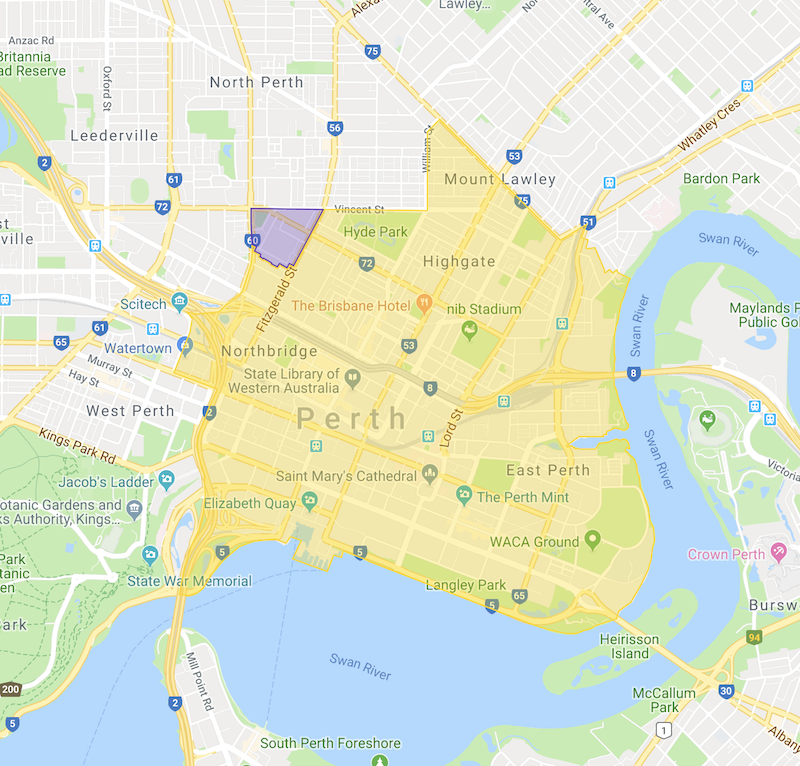
Local Intake Area Map - Please note: To find out if your address is in our area, please click on the 'Local Intake Area Map' link and type your address in the red search bar. If your address is in the yellow area, you are in our intake area. If your address is in the purple area, you are able to choose between North Perth Primary School and Highgate Primary School. If you reside outside of this area, we are unable to enrol your child in our school.
Intensive English Centre Boundary Map
Highgate Primary School is a local intake school.
The Principal will enrol an eligible child whose usual place of residence is in the local intake area for the school (Pre Primary to Year 6).
Please Note: Kindergarten is not compulsory. If you are in the local intake area and the school is at its maximum capacity of enrolled Kindergarten students, your child will be placed on a waitlist and you will be notified when a place becomes available.
The school will enrol students under the following priorities (Pre Primary to Year 6):
- All children whose usual place of residence is located within the local intake area for Highgate Primary School will be offered an enrolment.
If, and only if, there is spare capacity:
- Students who live outside the local intake area, and who have siblings currently enrolled at the school.
- Further places will be allocated based on nearest to the school basis.
This map is provided as a guide. Please note that in some cases only one side of the street falls within the boundary. Further clarification of the boundary should be made to Highgate Primary School 9253 2700.
_______________________________________________________________________________________
The local intake boundary is gazetted by the State Government.
The following defines the local-intake area of this school (YELLOW ZONE):
From the intersection of Vincent Street and Fitzgerald Street, east along Vincent Street to William Street, north and north east along William Street to Walcott Street, south east along Walcott Street to Lord Street, north east along Guildford Road through the subway to East Parade, south along East Parade to Pakenham Street, south east along Pakenham Street and its south easterly extension to the Swan River foreshore, south and generally west along the Swan River foreshore to the Narrows Bridge, north along the Mitchell Freeway to Wellington Street, west along Wellington Street to Sutherland Street, north along Sutherland Street to the Mitchell Freeway, east along the Mitchell Freeway to the Charles Street off-ramp, north along the Charles Street off-ramp and Charles Street to Cowle Street, south east along Cowle Street to Fitzgerald Street, and north east along Fitzgerald Street to Vincent Street. The boundary parts of Vincent Street (south side), William Street (east side), Walcott Street (south west side), Wellington Street (north side), Sutherland Street (east side), Charles Street (east side) and Fitzgerald Street (east side) are included within the local-intake area of this school. The boundary parts of Guildford Road (both sides), Pakenham Street (both sides) and Cowle Street (both sides) are excluded from the local-intake area of this school.
Students who reside in the following area have the option of attending either Highgate Primary School or North Perth Primary School (PURPLE ZONE):
From the intersection of Charles Street and Vincent Street, east along Vincent Street to Fitzgerald Street, south west along Fitzgerald Street to Cowle Street, north west along Cowle Street to Charles Street and north along Charles Street to Vincent Street. The boundary parts of Vincent Street (south side), Fitzgerald Street (north west side), Cowle Street (both sides) and Charles Street (east side) are included within this optional area.
| Note |
| The local-intake area maps are based on a written description of the local-intake area (LIA) for the school as published in the WA Government Gazette. Although the map closely represents the LIA description, for some houses near the boundary (especially on street corners), it may be necessary to refer to the written description. The street address of a residence is used to determine whether that dwelling is inside a particular LIA. While local-intake areas for most schools do not change from year to year, changes may be made to local-intake areas as required. Such changes are published in the WA Government Gazette and subsequently the local-intake area map will be updated. |